

DRONE SERVICES
Accurate site analysis to support your decision-making

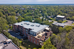
Drone & Surveying | Aerial capture and geospatial data
At DeBOX, we use professional drones to capture, analyze, and document sites with precision.
From visual capture to LiDAR and photogrammetry data, we turn environments into actionable information.
The challenge
-
Limited site visibility
-
Difficult or incomplete surveys
-
Fragmented field data
Result: reduced accuracy and slower decision-making.
The DeBOX solution
We combine:
-
high-resolution aerial capture
-
drone-based surveying
-
structured 3D data
to deliver clear and reliable site insights.
Applications
-
Construction & engineering
-
Surveying & mapping
-
Real estate development
-
Inspection & maintenance
Technologies
-
LiDAR drone
-
Photogrammetry
-
4K photo & video
-
360 imaging
Deliverables
-
Orthophotos
-
3D terrain models
-
Point clouds
-
Mapping data
-
Aerial visuals
Process
-
Site analysis
-
Flight planning
-
Data capture
-
Processing
-
Structured delivery
Compliance
Certified pilots and full regulatory compliance.
Positioning
Drone technology is a strategic tool for site understanding and planning.
Why DeBOX
We combine aerial capture, data processing, and technical expertise to deliver reliable site intelligence.
Realizations made by drone - Topography - Photos & videos
Topography - Drone - Scan to BIM
HDR | 4K Photographies
 |  |  |
|---|---|---|
 |  |  |
 |  |  |
 |  |  |
 |  |  |
 |  |  |
 |  |