Residential real estate sector
Whether promoting or selling a property, the relevance of comprehensive, quality marketing is an essential element. Our packages adapted to different types of projects present high-end solutions aimed at optimizing the quality of your promotional tools. We use Matterport 3D technology to scan spaces to generate virtual tours.
 |  |  |
|---|---|---|
 |  |  |
 |  |  |
 |  |  |
 |  |
3D VIRTUAL TOURS | 4K
In addition to offering full space accessibility, 3D virtual tours are excellent information gatherers.
The various tools allow the user to view the property from all angles, take measurements, consult relevant documentation, listen to audio content as well as watch videos.
Virtual tours are easily shareable in the form of a hyper link.
AERIAL PHOTOGRAPHS TAKEN BY DRONE
Our drone services consist of capturing high altitude images by taking aerial shots. Its HDR photographs and 4K video.
Aerial shots taken by drone are excellent tools for presenting the environment in which a property is located. They offer a complete view of the vacant lot, the exterior inclusions of the property as well as certain aspects of the rental.
They can be presented in the form of photographs and videos.
Altitude of 120 meters (393 feet)
4K image quality
Frequently used type of drone: DJI Mavic Pro Drone
 |  |  |
|---|---|---|
 |  |  |
 |  |  |
 |  |  |
 |
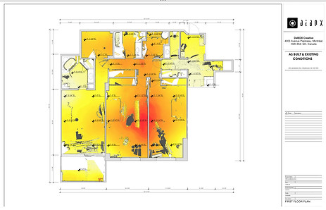
2D ARCHTECTURAL DIAGRAMS | Floor plan, elevation
2D architectural schematic plans show the general appearance of the property. It allows you to visualize the structure of the building, the configuration of the rooms as well as the dimensions of the rooms.
The plans are produced and adapted according to the client's needs. They can be shared in revit, dwg and pdf format.